


DELMARVA - As a shortwave trough slides across Delmarva Wednesday night and into Thursday, an upper-level ridge is forecast to build eastward, with its axis cresting our region by Friday or Friday night. At the surface, weak high pressure will shift east of our area by Thursday. Meanwhile, a weak low pressure may traverse northern Delmarva on Thursday, accompanied by a weak cold front that could move south across our area in the afternoon.
With the arrival of the ridge aloft on Friday, surface high pressure centered to the north-northeast is forecast to extend southward into our area, maintaining a frontal boundary to our southwest.
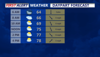
Weather-wise, expect increased cloudiness at times due to the weak nature of the system and limited moisture availability. A warm air mass will prevail on Thursday, but coastal areas will likely remain cooler due to sea breeze effects. Following the passage of the weak system, some cooling is anticipated for Friday, although daytime temperatures will still be above average. Coastal temperatures will again be cooler, influenced more by marine conditions.