


DELMARVA -
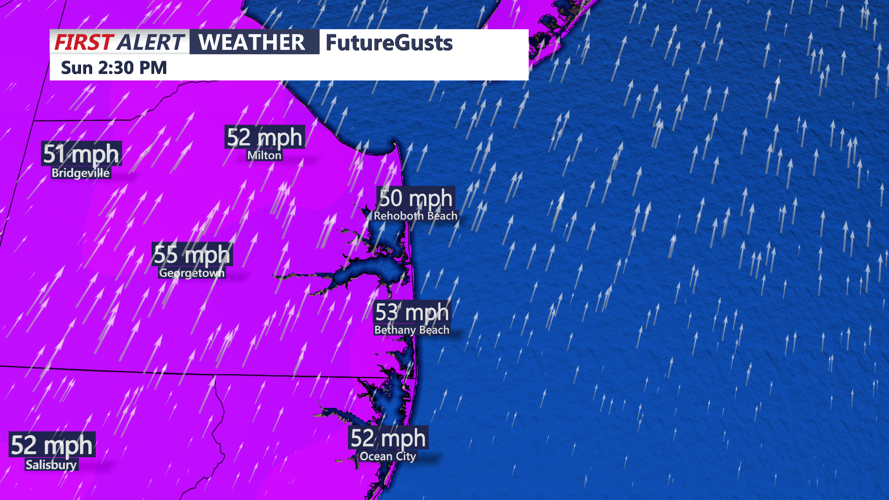
Sunday, February 16 – Stormy and Windy
- High Wind Warning: From 10 a.m. Sunday to 6 p.m. Monday.
- Winds: West 20-30 mph, gusting up to 60 mph.
- Rainfall: Periods of heavy rain in the morning, tapering off by late afternoon.
- Temperature: High of 65°F (18°C), dropping rapidly as a cold front moves through.
- Impacts: Tree damage, power outages, and hazardous travel, especially for high-profile vehicles.
Monday, February 17 – Cold and Windy
- Winds: Still gusty, west 25-35 mph, gusts up to 55 mph in the morning.
- Temperature: Highs only reaching 41°F (5°C), with wind chills in the 20s.
- Conditions: Dry but much colder. Winds gradually weaken by the evening.
Tuesday, February 18 – Frigid and Dry
- Temperature: Highs only in the low 30s, with overnight lows dropping into the teens.
- Winds: North 10-15 mph, making it feel even colder.
- Conditions: Dry, but clouds will increase ahead of the approaching storm system.
Wednesday, February 19 – Snowstorm Incoming
- Winter Storm Watch Likely: A strong low-pressure system is forecast to impact the region.
- Precipitation Type: Snow expected to begin midday and intensify into the evening.
- Temperature: Highs around 29°F (-2°C), lows in the low 20s.
- Accumulations: European ECMWF model suggests 6-10 inches of snow for Sussex County and Ocean City, with higher totals possible if the system tracks slightly farther north.
- Impacts: Snow-covered roads, reduced visibility, and power outages due to heavy snowfall and gusty winds.
Thursday, February 20 – Lingering Snow and Bitter Cold
- Conditions: Snow tapering off early, with clearing skies by the afternoon.
- Temperature: Highs struggling to reach 30°F (-1°C), with overnight lows around 15°F (-9°C).
- Winds: North 10-20 mph, keeping wind chills in the single digits.
- Travel Outlook: Roads may remain hazardous due to refreezing.
Key Takeaways & Preparations:
- Sunday-Monday: Expect damaging winds, heavy rain, and power outages. Secure outdoor objects and avoid unnecessary travel.
- Midweek Snowstorm: Prepare for a major winter storm with heavy snowfall and potential travel shutdowns. Stock up on supplies, as conditions may be dangerous from Wednesday into Thursday.
- Cold Snap: Arctic air will settle in after the storm, keeping temperatures below normal through late week.
Stay updated with the latest forecasts, and be prepared for rapidly changing conditions.