

Weather Alert

Latest Weather

Meteorologist Chris Mastrobuono has the latest on tropical humidity on Delmarva, highs in the low 90s, feeling like 97 to 103, an isolated t-storm is possible this evening that could produce damaging winds. The heat and very high humidity continues into the weekend with a chance of thunderst…

Soupy, Hot Conditions Persist With Isolated Evening Storm Chances Through Weekend

DELMARVA -- Hot and very humid conditions will remain firmly in place across Delmarva with little significant change expected through the first part of next week.

A stagnant weather pattern is developing across the region, with Bermuda high pressure remaining offshore and a steady supply of very warm, moisture-rich air continuing to flow into the peninsula. That combination will keep temperatures elevated and humidity levels particularly uncomfortable for several more days.

Heat index values across Delmarva will frequently approach 98 to 103 degrees, especially during the afternoon hours. While actual high temperatures will generally reach the upper 80s to lower 90s, the abundant humidity will make it feel considerably hotter.

Along with the heat comes a nearly daily opportunity for showers and thunderstorms.

Thunderstorm coverage is expected to increase to our west later this afternoon and into the evening as an upper-level disturbance approaches the region.

Storms developing farther west are expected to organize and move eastward during the afternoon and evening. As they approach Delmarva, some weakening is possible due to the loss of daytime heating, particularly closer to the coast. Even so, parts of the peninsula remain under a Marginal Risk for severe thunderstorms, with damaging wind gusts the primary concern.

The atmosphere will also contain an exceptional amount of moisture. Precipitable water values near 2 to 2.25 inches could allow stronger thunderstorms to produce rainfall rates of 2 to 3 inches per hour.

Because storms should continue moving, widespread flash flooding is not expected. However, any thunderstorm repeatedly affecting the same community or producing torrential rainfall over an urban area could result in localized flooding.

Tonight will be another very warm muggy night in the mid to upper 70s, with some patchy fog possible. 

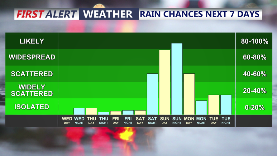
Saturday features mostly sunny hot and humid conditions with highs in the low 90s and heat indices 98 to 103. 

Additional showers and thunderstorms are possible Saturday, although storm coverage may be somewhat less widespread than Friday.

The timing remains uncertain, but current indications suggest the better opportunity for storms could arrive later Saturday evening or even overnight as a weak cold front approaches.

Delmarva remains under a Marginal Risk for excessive rainfall Saturday, meaning isolated flash flooding will remain possible wherever the heaviest storms develop.

Some thunderstorms could also produce locally strong or damaging wind gusts. 

A weak cold front should pass through Delmarva by early Sunday.

The front will not bring dramatically cooler temperatures, but it should allow slightly drier air to move into the region. Sunday therefore appears to offer a short-lived break from the most oppressive humidity and a somewhat lower chance for thunderstorms.

High temperatures will still reach the upper 80s to lower 90s, so it will remain hot despite the modest improvement in humidity. The break will not last long.

Moisture will quickly return to Delmarva by Monday, bringing another surge of hot and very humid weather Monday and Tuesday.

Thunderstorm chances will increase again as stronger winds aloft and additional atmospheric disturbances move through the region. The setup could support a somewhat greater threat for severe thunderstorms early next week, particularly from storms capable of producing damaging wind gusts.

Localized heavy rainfall will remain possible as well, although the flash flooding threat may become somewhat lower than during the wetter pattern experienced recently.

The exact timing and intensity of storms Monday and Tuesday remain uncertain, but both days currently favor continued heat, high humidity and opportunities for thunderstorms.

A stronger cold front is expected to approach Delmarva late Tuesday or Wednesday.

That front could finally push the deepest tropical moisture out of the region and bring a more noticeable reduction in heat and humidity.

Thunderstorms may accompany the front, and additional afternoon storms could remain possible even behind it depending on the upper-level pattern.

Until then, Delmarva residents should prepare for several consecutive days of oppressive humidity, dangerous afternoon heat indices and periods of thunderstorms capable of producing torrential rain and locally damaging winds.

Milton, DE

Right Now
92°
Sunny
  • Humidity: 49%
  • Feels Like: 99°
  • Heat Index: 99°
  • Wind: 12 mph
  • Wind Chill: 92°
  • UV Index: 9 Very High
  • Sunrise: 06:07:51 AM
  • Sunset: 08:05:28 PM
  • Dew Point: 70°
  • Visibility: 10 mi

Today

Abundant sunshine. Hot. High 92F. Winds SW at 10 to 15 mph.

Tonight

Some clouds. A stray shower or thunderstorm is possible. Low 76F. Winds SW at 5 to 10 mph.

Tomorrow

Generally sunny despite a few afternoon clouds. A stray shower or thunderstorm is possible. High 93F. Winds SW at 10 to 15 mph.

Next 12 Hours

Time
Temp
Precip
3 PM
92°
1%
3 PM
92°

Wind: SW @ 13 mph

Precip: 1% Chance

Humidity: 49%

Wind Chill: 92°

Heat Index: 99°

UV Index: 7 High

Visibility: 10 mi

Dew Point: 70°

4 PM
92°
1%
4 PM
92°

Wind: SW @ 13 mph

Precip: 1% Chance

Humidity: 50%

Wind Chill: 92°

Heat Index: 99°

UV Index: 5 Moderate

Visibility: 10 mi

Dew Point: 70°

5 PM
90°
1%
5 PM
90°

Wind: SW @ 12 mph

Precip: 1% Chance

Humidity: 54%

Wind Chill: 90°

Heat Index: 98°

UV Index: 3 Moderate

Visibility: 10 mi

Dew Point: 72°

6 PM
90°
1%
6 PM
90°

Wind: SW @ 12 mph

Precip: 1% Chance

Humidity: 56%

Wind Chill: 90°

Heat Index: 98°

UV Index: 1 Low

Visibility: 10 mi

Dew Point: 72°

7 PM
88°
1%
7 PM
88°

Wind: SW @ 10 mph

Precip: 1% Chance

Humidity: 59%

Wind Chill: 88°

Heat Index: 96°

UV Index: 0 Low

Visibility: 10 mi

Dew Point: 72°

8 PM
85°
7%
8 PM
85°

Wind: SW @ 8 mph

Precip: 7% Chance

Humidity: 65%

Wind Chill: 85°

Heat Index: 92°

UV Index: 0 Low

Visibility: 10 mi

Dew Point: 72°

9 PM
83°
15%
9 PM
83°

Wind: SW @ 6 mph

Precip: 15% Chance

Humidity: 70%

Wind Chill: 83°

Heat Index: 89°

UV Index: 0 Low

Visibility: 10 mi

Dew Point: 72°

10 PM
81°
20%
10 PM
81°

Wind: SW @ 6 mph

Precip: 20% Chance

Humidity: 77%

Wind Chill: 81°

Heat Index: 86°

UV Index: 0 Low

Visibility: 10 mi

Dew Point: 73°

11 PM
79°
15%
11 PM
79°

Wind: SW @ 4 mph

Precip: 15% Chance

Humidity: 80%

Wind Chill: 79°

Heat Index: 85°

UV Index: 0 Low

Visibility: 10 mi

Dew Point: 73°

12 AM
79°
15%
12 AM
79°

Wind: SSW @ 5 mph

Precip: 15% Chance

Humidity: 81%

Wind Chill: 79°

Heat Index: 84°

UV Index: 0 Low

Visibility: 10 mi

Dew Point: 73°

1 AM
79°
15%
1 AM
79°

Wind: SSW @ 6 mph

Precip: 15% Chance

Humidity: 82%

Wind Chill: 79°

Heat Index: 84°

UV Index: 0 Low

Visibility: 10 mi

Dew Point: 73°

2 AM
78°
15%
2 AM
78°

Wind: SW @ 6 mph

Precip: 15% Chance

Humidity: 84%

Wind Chill: 78°

Heat Index: 83°

UV Index: 0 Low

Visibility: 10 mi

Dew Point: 73°